Wow—after reading through the text and watching the YouTube video—I am just stunned and confused. I didn’t realize the relationship between the different temperatures and water. I can see now how the weather is very important and how we can track it. However, sometimes it is very unpredictable at times.
Well…as for the differences between the jet streams and the wind and weather it all comes down to hot and cold. I was thoroughly confused when watching the videos and reading the slides at understanding the way the weather is affecting the different areas of the earth. I will say that when using digital resources, I enjoy the videos more than the slide shows. I think it’s because someone may be talking to me other than me having to read the slides and being thoroughly confused at the vocabulary and terminology that I haven’t even used for what seems like forever!
In reflecting on the information in this portion of Module 6, I am sure of a few things. When it comes to cold water and warm water ---the Walker cell was explained well for me. I can say that the forces were clear. The cold water from the ocean floor is pushed up and exchanged with the warm water at the edge of the coastline. (Which I was shocked to know…but it makes incredible sense.) I have also made connections between weather and how the ocean plays a huge part of this. I live on an island, in fact I have an ocean view and watch the huge waves take control of our island life. The difficult thing for me was understanding the jargon of this lesson. I did rewatch the YouTube video and read through the slideshow from PBS a few times to try and understand the content….I am still confused!!!
Tuesday, November 30, 2010
Sunday, November 28, 2010
Module 6: Part 1
The Arctic is a wasteland for horrible pollution layovers. It seems to me that the pollution is gravitating to the poles and the Arctic is getting the most of it. The wind is proving to be one of the major factors of this pollution. We are getting the smoke and pollution from faraway cities and is caused by tiny particles. I am so shocked from watching the videos of the after affects of this. Beginning with the contamination of the food sources so many relies on for existence.
This stems from the moms who nourish themselves with the contaminated meat from the top of the food chains to the infants born with the most strangest levels of PSB. It boggles my mind and it really hurts me to know the people who still exist from the land and the land is not being kind to them. Where do we lay the blame? There are parents who truly believe that survival is from the land and the land is not being treated right.
These videos really hit me---and I was saddened by that. I was really affected by the sole existence of the whaling that many northern tribes rely on---from Greenland through Canada to our homeland in Alaska.
How can the industrialized societies help? This is a question much further in their hands than ours. How can they help with pollution? I was very shocked that they travelled to Alaska to compare the levels of air (Alaska supposedly being the most clean) and what disappointment or reality it was to them.
Aviation is very important to the life we live in Alaska. Having been raised on an island I am aware of that vital existence. I have also been a resident in a village on our island with my initial year of teaching. Aviation brought me my groceries and the fuel we needed when the village ran out and the barge was weeks from arrival. Being an Alaskan aviator is also very unique in it’s trade. They also get paid on the jobs/work that they perform so when the weather isn’t great…they don’t fly and therefore don’t get paid.
Being a pilot of native heritage---knowing the lay of the land and the way of the winds is imminent. Native pilots have been trained at the way the weather holds onto the day or days ahead of them. Watching the winds and taking the time to really watch the tides and weather patterns that have been imbedded into them is what they hold as an asset. These are traditional ways of knowing the weather that have been bestowed on them from their elders.
When I viewed the bush pilot video- I immediately thought of my husband. He is a fisherman who watches the weather ---before a trip----and really knows the weather patterns. He also has many digital devices on his vessel to help and aide him in his career. To a bush pilot, I believe it’s important to have the proper gear to help with their manual flight and also their gear use flight. By this I mean---being able to see what is happening and what they can’t see visually but can see with the equipment.
We have seen how times are changing and how the weather patterns are changing. Like I have said before, my husband watches the weather each night and sits and wonders where the patterns are coming from.
Tuesday, November 16, 2010
Module 5: part 1
In traditional native ways, the people would use the moon and the tides to determine what was available for use/ to eat. The video talked about the size of the moon- and I find that interesting because on my island the elders talk about the tides and seasons differently. Mainly they talk about how the animals would “talk” to them, therefore they knew what animals were available.
The ocean is extremely important to all Alaska Natives. As, Lucille Davis (a relative of mine) discussed, salmon was the ultimate food for us natives on the island during the summer time. Lucy grew up in Karluk, the village that my mother did too. In fact, my grandfather had the largest smokehouse in that village with the capacity to smoke a thousand fish for the village. It was bigger than their banya! It was also about no waste---whatever wasn’t used was used for the garden or also placed back into the ocean as feed for other animals.
Where I come from, we have many cultural resources…the ocean and the land as well as the sky. Hunting comes in all sources, but allow us to survive and prosper. I was born in the 70’s and heard of the changes as a child and now see them as an adult. Our island in the 70’s was known as the King Crab capital of the world. We had the most abundant amount of King Crab. I could recall as a child, going to the docks and watching the crab crawling up the pilings. Now we are not allowed to subsistence catch but one! BUT one!!! Was it the change in climate or the mismanagement of the amount of catch? Ask an elder in our area and it was the mismanagement----of all things that are becoming scarce.
I believe that the value of using Teachers’ Domain in learning shares both avenues-western and native. We get to see the value of the elders voice and it incorporates the experience and education of the professional folk too.
Sunday, November 14, 2010
Module 4: Google Earth
Well, I did download Google Earth and spent some time figuring out how to measure distance…with little success. I did however; find success in straight-line measurement. So my mileage is probably short because I could only do straight lines with a bit of success. Okay, I calculated 1495.19 miles on the archipelago. I began with the last bit of the state before it broke into islands. I also came up with 4682.09 miles for the Aleutian Trench.
I use Google Earth with my students on their IPADS each week and it is very successful. I have one student who recently moved from Tennessee and was able to locate her old home and share it with the class---what a great teaching tool!
I use Google Earth with my students on their IPADS each week and it is very successful. I have one student who recently moved from Tennessee and was able to locate her old home and share it with the class---what a great teaching tool!
Module 4: Earthquakes and Tsunamis
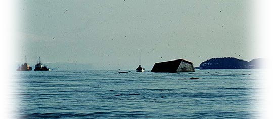
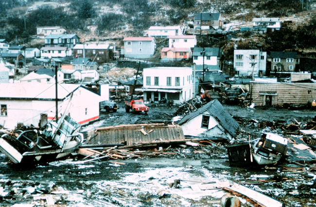
The tectonic forces that caused the earthquake were with the Pacific Plate sub ducting under Alaska. This pressure caused the earthquake to happen. After watching the video of Valdez I began to make connections to the hometown of my grandmother-Afognak village. The devastation from this earthquake caused a tsunami that destroyed her village. Just as Valdez relocated, the people from the village of Afognak relocated to the villages of Port Lions and Ouzinkie.
You can still walk through the old Village of Afognak and see many houses still standing. At one time I walked through to see the town store and post office in the lagoon.
People have used this experience to be more aware of earthquakes and tsunamis. In our town of Kodiak there are tsunami warning alarms throughout. Each and every Wednesday we have tests of these alarms at 2:00 p.m. to ensure they are working and ready to go. If the alarms go off at any other time, we know it’s business and not a testing time.
I have taught many lessons from the ATEP (Alaska Tsunami Education Program) to show my students about the 1964 Earthquake and Tsunami. We have viewed elder interviews and read stories that relate to this topic. I feel it is vital that our students know the importance of being educated about earthquakes and tsunamis---we do live on an island!!!
Module 4: Cultural Connections Part 1
I really enjoyed watching all three of the videos. I can say there are plenty of similarities between the people of Hawaii and the people of Alaska. We share the “island” living and the coastline eating. It is always neat to watch the similarities between the East Coast and the Pacific Ocean. We are full of fisherman and fishing lifestyles. I didn’t realize there were whaling ports in Massachusetts? That shows how little I know about the East Coast.
The differences between Massachusetts and the island lifestyles are the population make-up. The Massachusetts folk are a Heinz 57 of culture and diversity. Most of the Hawaiian footage was that of Hawaiians, as well as the footage from Alaska. I also felt that my hometown, Kodiak, fits in well with the Nanwalek culture and people.
EXTEND
• What other cultures do you know that live in the shadow of volcanoes?
• How does living on volcanic islands influence culture?
• What other related stories do you know?
When I think of volcanoes----I think of countries with many islands. Of course we have the Hawaiian islands, The Aleutian Islands, and….what came to mind for me was the Indonesian Islands. Perhaps it’s been the current happenings over in that area of the world, but I thought of them first. I also think of the Filipino People who are close and would be affected by the volcanic activity.
I live on an island that is shadowed by volcanoes regularly. With the constant worry of volcanic activity (most recently Mount Redoubt) on our island we are always prepared. Our ancestors have done a great job of teaching us, through storytelling) how important it is to be prepared. With the introduction of websites as http://www.avo.alaska.edu/
We are very fortunate to be able to monitor activity. In fact, when Kevin Costner was making the movie, The Guardian, he chose not to come to Kodiak with fear he may be stuck!
Science can impact indigenous cultures and their way of life in both positive and negative ways. Through modern day monitoring we are able to inform citizens very quickly of things as earthquakes, volcanic eruptions and tsunami warnings. For this, we are quite fortunate. However, when we talk about interrupting religious areas to build stations, we are not taking into consideration the history and the importance of their way of life. Often, things happen for a reason---as my grandmother instilled into me. Science is a way of life---it has always been. Nowadays we just don’t do it by watching the weather, or watching the tides, or the constellations in the sky.
I am also fortunate to have spent some time in Hawaii and watch the way their stories have shaped their lives…. just as my heritage has shown me.
Quick story: My husband and I spent a week on Rarotonga, Cook Island for our honeymoon. We flew down and met the most remarkable lady, Peta. Peta was a native to the island. She was of simple existence, such as myself, and couldn’t comprehend the lifestyles of those who visited her island. We spent the week getting to know each other very well and when we departed, her last words to me were---thank you for being my friend, North Pacific Islander. Although we were of two different worlds, we were of very similar beliefs. We had become friends through our similar values of being Pacific Islanders.
Tuesday, November 2, 2010
Module III: Landscapes of Life
I am beginning to recall information from my college days in a science course at UAF: Earthquakes, Volcanoes and Glaciers. Throughout my life--I haven’t been strong with the area of science....I was so excited to begin to teach place-based learning and it allowed me to shine with my LOCAL experiences...and as I reviewed the resources we were assigned this week, It also brought back a lot of stories that were told while I was growing up in Kodiak. My family was affected by the 1964 Alaska Earthquake and the devastation that was to follow on Kodiak Island. The whole IDEA of a tsunami WAS/IS real for my family as they all were involved in the 1964 Kodiak Tsunami.
On another note, throughout the past few years, many teachers within our school district (and other districts) have been field testing some awesome teaching units in the Alaska Tsunami Education Program. This was a grant funded project through the University of Alaska Fairbanks that really brought to light the whole world of earthquakes and tsunamis. (The website is listed under great resources.)
And when we talk about erosion and landscape changes, we see it in Kodiak quite regularly. We are an island in the Gulf of Alaska and we are in the midst of a lot of tidal activity and change. In fact, the two villages in which my families were born/raised are experiencing such change. My mom was born on the westside of our island in a village called---Karluk.
As a child I remember visiting my grandparents home and seeing the historical buildings throughout the many faces of the village. Well, to put it blankly---much of Karluk has FALLEN into the lagoon. The old village was built on the side that experiences a lot of wind and tide change. The erosion has caused the OLD side to fall into the lagoon. And to relate to my mom’s side of the family--my dad’s village is experiencing much of the same landscape changes. In fact the area or POINT that was named for it’s purpose---Graveyard Point----is now eroding so that the buried are beginning to fall into the water. Both places I speak of are experiencing erosion problems.....ones that the originators had no idea of. That makes me wonder-----has erosion increased? Or did people assume that building so far off the coast would allow for SECURITY?
When I talk with students about erosion and change with the landscapes around our island---I bring up two particular locations. These are the Buskin River and the Pasagshak River. These two locations are great salmon fishing rivers where people are often found from May until September. The discussion we often have include--WHY DO THE MOUTHS OF THE RIVERS LOOK DIFFERENT EVERY YEAR? Each of these rivers hang off of the main waters and do not have shelter to protect their shores....therefore the mouths change each year....great discussion on erosion and landscape,etc.
Great Resources
This website has ALOT of information about educating children about earthquakes and tsunamis. It has great resources and lessons.
http://www.aktsunami.com/
This website is connected to one of our local native corporations, Afognak Native Corporation. They have began to fund and develop lessons that incorporate history and language. You will see lessons/ units to teach on local earthquakes and tsunamis.
http://www.afognak.org/education/index.php
Subscribe to:
Posts (Atom)